1. Introduction to Spatial Analytics
Learning goals for this lesson
After this week’s tutorial, you should be able to understand:
What is special about spatial?
What is the typical process workflow for doing spatial analysis?
- Key definitions and their differences/similarities:
spatial analysis; GIS; geocomputation; GIScience; geographic data science; quantitative geography, ..
What are typical application areas for spatial analytics?
What kind of contemporary spatial data science challenges exist?
Resources
This week’s literature and video material that you can go though on your own time.
Literature:
de Smith, M. Goodchild, P. Longley (2020) - Geospatial Analysis (free online book):
Singleton, A. & D. Arribas-Bel (2019) - Geographic Data Science :cite:`Singleton2019`
Wolf L.J. et al. (2020) - Quantitative geography III: Future challenges and challenging futures. :cite:`Wolf2020`
Videos:
Spatial Data Science overview by Luc Anselin (2016):
What is spatial data science? (by CARTO):
What is special about spatial?
The question above is a classical discussion topic among spatial scientist and geographers, especially when we are discussing with someone who comes outside of our domain (i.e. great majority of the people). For us, knowing why geography matters is a rather obvious thing (as Waldo Tobler famously put it around 50 years ago), but it is also good to remind us in a bit broader terms, what is it that make this field of ours special. The following presentation gives you a brief introduction to the topic:
Analytical workflow
Before diving into the world of spatial analytics, let’s start by taking a look at the typical workflow that applies to spatial data science (as well as to any kind of science, really). Figure 1 represents an overview of the typical workflow for spatial analysis process (see more details from the following sections). During the course, these steps will become extremely familiar to you, as we are going to repeat the same processing steps on each week.
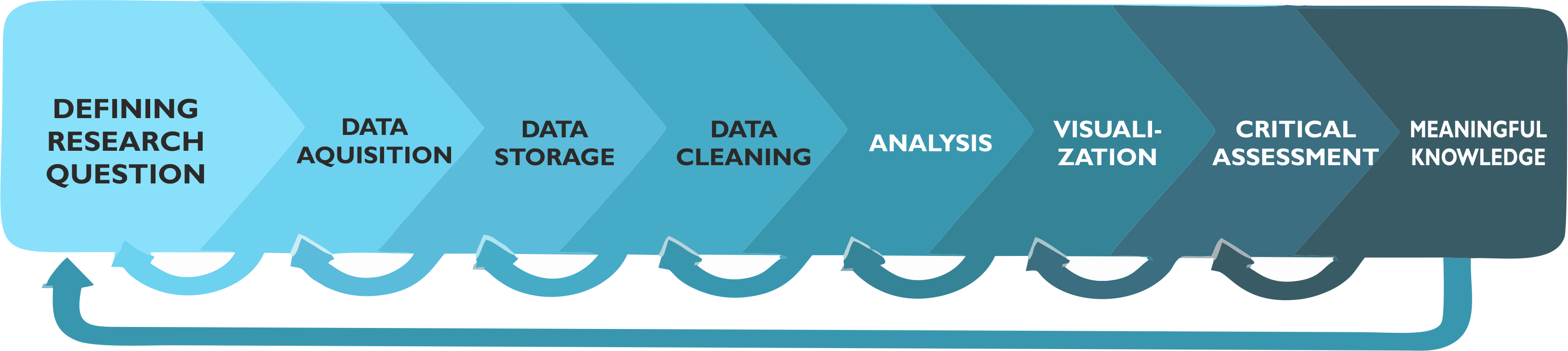
Figure 1. Typical spatial analysis workflow consist of various steps that start from defining the research question and (ideally) end with meaningful information about the topic that was analyzed. (adopted from :cite:`Toivonen2019`)
Another useful and a bit more generic analytical framework is to think the methodological work as a sequence of 5 steps that is called as PPDAC consisting of Problem, Plan, Data, Analysis, Conclusions :cite:`MacKay2000`:
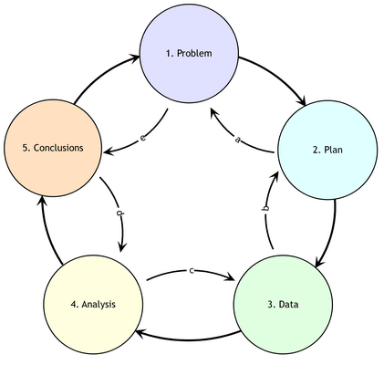
Figure 2. A PPDAC approach as an iterative process: Although clockwise sequence (1→5) applies as the principal flow, each stage often feeds back to the previous stage. (Source: de Smith et al. (2020) )
Step 1 - Defining the question/objectives
All analytical work (and doing science in general) starts by defining the research question and/or specifying the objectives for the work. Typically this step starts by getting an idea or having a problem that requires solving. You most probably have at least once gotten a “light bulb” 💡 moment, or been truly wondering some aspect of life or technology that you don’t yet understand. With the initial idea, typically follows a rigorous search for information and discussing with others about the idea/problem. In some cases, it turns out that no-one has yet answered to your question, or developed a technical solution for the problem. If this is the case, then you start by planning how to proceed with the problem at hand.
Step 2 - Data acquisition
Nothing here. Placeholder for demo purposes.
Step 3 - Data storage
Nothing here. Placeholder for demo purposes.
Step 4 - Data cleaning
Nothing here. Placeholder for demo purposes.
Step 5 - Analysis
Nothing here. Placeholder for demo purposes.
Step 6 - Visualization
Nothing here. Placeholder for demo purposes.
Step 7 - Critical Assessment
Nothing here. Placeholder for demo purposes.
Step 8 - Outcome: Meaningful knowledge
Nothing here. Placeholder for demo purposes.
Definitions: What is spatial analysis, really?
“A belowed child has many names” …
Warning
No contents here (this is just a demo). This part would introduce the students what is meant by:
spatial analytics
GIS
geocomputation
GIScience / spatial data science / geographic data science
geoinformatics / geoinformation technology
quantitative geography
Focus is to understand some of the historical reasons, debates and reasoning why all of these different domains have emerged and how they differ from each other.
Application areas for spatial analysis
Warning
No contents here (this is just a demo). This part would introduce the students what kind of application areas and spatial analysis methods there exists.
Contemporary challenges in spatial data science
Warning
No contents here (this is just a demo). This part would introduce the students what kind of contemporary challenges exist for spatial data science, such as:
how to handle ever growing and massive spatial datasets (big geodata)
how to handle sensitive spatial data in such a manner that it does not violate privacy (e.g. movement data, geosocial data etc.)
how to utilize modern machine learning frameworks (such as neural nets) with spatial data to make e.g. more accurate models and predictions
classical issues: - how to deal with uncertainty in spatial data - how to democratize spatial analysis (e.g. with online spatial analysis platforms)